Upcoming BAC Events

Sep
27
Wed
7:00 pm Brooklyn Action Corps General Me... @ Sacred Heart Villa & Virtual
Brooklyn Action Corps General Me... @ Sacred Heart Villa & Virtual
Sep 27 @ 7:00 pm – 8:30 pm
Brooklyn Action Corps General Meeting @ Sacred Heart Villa & Virtual | Portland | Oregon | United States
The public is encouraged to attend the Brooklyn Action Corps (BAC) general public meetings. Typically held on the 4th Wednesday of every other month, i.e. January, March, May, etc. Due...
Oct
4
Wed
7:00 pm Brooklyn Land Use & Transportati... @ TBD
Brooklyn Land Use & Transportati... @ TBD
Oct 4 @ 7:00 pm – 8:30 pm
The meeting will be held as a hybrid meeting, both in-person and on Zoom. You can join from your computer, tablet, or smartphone, or call in from a phone. https://us06web.zoom.us/j/97619486898?pwd=SlBVR3FId0xRQ2hpeWxBWCsxa0IzQT09...
Oct
5
Thu
7:00 pm Brooklyn Climate Community Open ... @ The Chomp
Brooklyn Climate Community Open ... @ The Chomp
Oct 5 @ 7:00 pm – 8:30 pm
Brooklyn Climate Community Open Meeting @ The Chomp | Portland | Oregon | United States
For anyone who is concerned about the climate crisis and wants to do something about it collectively. Contact: climate at brooklyn-neighborhood.org You may also join the Slack.

What happened to Brooklyn Creek?

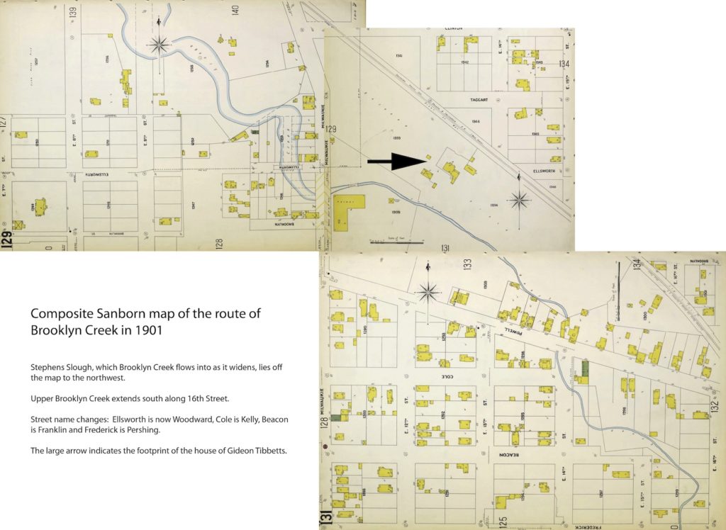
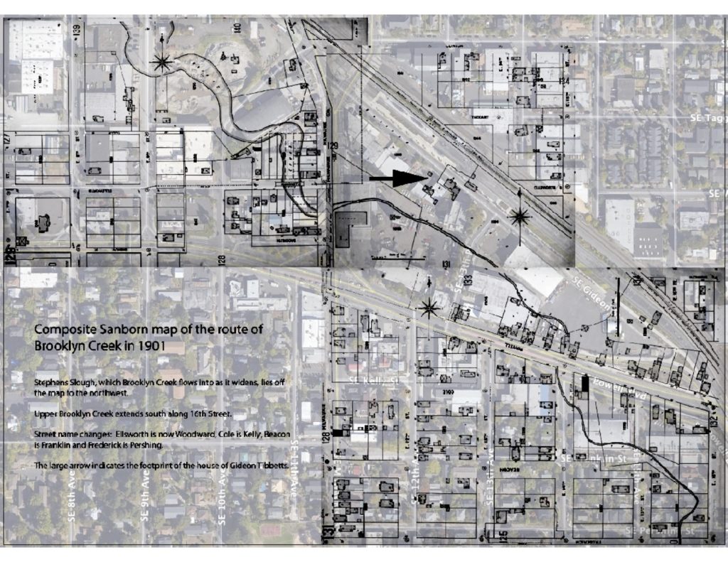
In the 1850s, when Gideon Tibbetts, the original donation land grantee of the area that would become the Brooklyn Neighborhood, first sited his farm and subsequent extensive apple and pear orchards, he chose fertile land on the banks of a creek that ran through his new property. As one of the first land grant holders on the east side of the river opposite the newly established townsite of Portland, he also built the first flour mill on the eastside, on the bank of that same creek, using waterpower to operate the mill wheels.

After satisfying the land grant requirements of personal use for 4 years, he began to sell farm sites, platting out and selling parcels of his claim for $10 to $50 per acre. The creek was used as a selling point – the area was called Brook Land in advertisements in the Oregonian to attract buyers. As the land was developed, the name became shortened to Brooklyn. For 50 years, as the area was absorbed into East Portland then Portland, Brooklyn Creek threaded its way through the community. Then, just after 1900, to control flooding and to allow more development, the city decided to bury the creek in a massive pipe draining into the Willamette. Brooklyn Creek was no more, existing only in memories or stories. Today, one can still hear Brooklyn Creek gurgling along underground at manholes on SE 16th Street.

Composite Sanborn map of the route of Brooklyn Creek in 1901
Stephens Slough, which Brooklyn Creek flows into as it widens, lies off the map to the northwest. Upper Brooklyn Creek extends along 16th Street. Street names changes: Ellsworth is now Woodward, Cole is Kelly, Beacon is Franklin, and Frederick is Pershing. The large arrow indicates the footprint of the house of Gideon Tibbetts. Click image for full size PDF.
1901 Brooklyn Creek map overlaid with current aerial photo of Brooklyn neighborhood
1901 Brooklyn Creek map overlaid with current aerial photo of Brooklyn neighborhood. Click image for full size PDF.


Leave a Reply

Weekly Email Newsletter


Social Media

RSS
Facebook
Instagram